Speaking of Antiquing – November 2019
People of a certain age will understand the love for and fascination with a paper map. The road map…folded in a specific way that only patience and agility can repeat. Kept in the glove box of the family car… as the key to destination precision.
In the 1860’s, Rand McNally published maps for the railroad system that was dominating inland travel. They later published many maps for the oil industry as oil was found throughout the country, using color and scale. In the early 1900’s, when the automobile took over the wagon roads, maps were needed to pinpoint destinations. Towns were as far away as one could walk in a day. In the Great Migration heading west in America, towns began where the travelers landed. I remember once commenting on a desolate town in Nevada, “Why would anyone want a town here?” The (joke) answer was that mom just refused to go any further. That is probably true of any number of towns scattered in this vast land. But where were they?
In 1918, numbered roads were introduced as a system of identifying highways. Later, interstate freeways dominated the landscape. Cartographers were an integral part in settling this country. The world was charted and graphed from the earliest of days. Many places were “discovered” by the ones who made the maps.
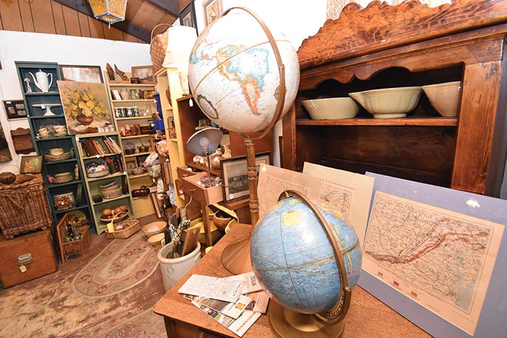
Vintage road maps and vintage globes pass through the shop frequently. Road maps were given free at gasoline stations. Local advertisers produced many, and Chambers of Commerce used them to draw visitors to the local attractions.
Globes are classic. They are fascinating. At first sight, one sees the earth is round. Divided in hemispheres by the equator we learn of the countries that cover the earth’s surface. We see the vastness of the oceans. We understand why Australia is “down-under.” Almost everyone had a globe in their homes. Geography was easy to learn when you could see how massive the earth is and how far places are from one another. Be it a tabletop or a free-standing globe, they are still interesting today even though we have maps on our phones and GPS in our cars.
Playing “spin the globe and stop it with your finger” just cannot be played on a phone. Globes hold the key to understanding circumference, longitude, latitude, time zones, regions, scale, and many life lessons. Many countries are no longer in existence. It is interesting to date globes by finding old and new countries.
“Teach your children well,” a theme of my generation, must continue in new generations where geography may not be taught with globes and pull-down maps of the world. Introduce your children to the wonders of the world by showing it to them. Let them spin it and then discuss where that finger landed.
 Margaret Barns is co-owner of Pickety Place Antiques & Collectibles located at 130 N. 4th Street in Jacksonville. LIKE them on