On Real Estate & More – May 2025
Editor’s Note: At press time Oregon Legislature has passed SB 83.
AS OF THE WRITING OF THIS ARTICLE, a bill intended to repeal Oregon’s controversial Wildfire Hazard Map and related property regulations was unanimously voted by the Senate Committee on Natural Resources and Wildfire to eliminate the Map and is now heading to the Oregon Senate for a vote.
The Wildfire Hazard Map was created in 2021 under Senate Bill (SB) 762, which directed the Oregon Department of Forestry to map out fire-prone areas in the state. Under SB 762, homeowners living in areas that are at a high wildfire risk face stricter building codes when making renovations and would also be required to reduce vegetation on their properties.
A provision created in 2023 prohibits insurance companies from canceling or declining to renew homeowners’ insurance policies or increase premiums based on the Wildfire Hazard Map. Despite this, the backlash against the Wildfire Hazard Map has persisted in part due to the public’s perception that increased insurance premiums and cancellations are related to the Map.
Oregon SB 83 would repeal the Wildfire Hazard Map, meant to identify parts of Oregon at high risk of wildfires but has become a source of anger from the public who believes it places an unfair burden on them. The bill next moves to the Senate floor for a vote; it would then need to pass the House and be signed by the Governor before becoming law but will likely pass.
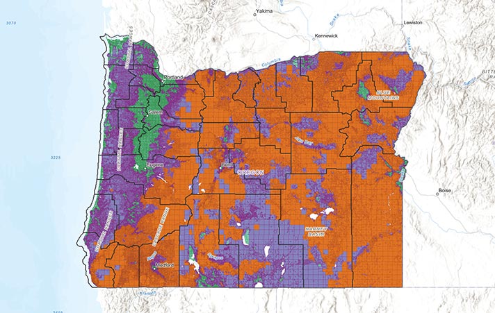
The Wildfire Hazard Map, which was released earlier this year and identifies areas of high wildfire risk, requires stricter building codes and creation of defensible space for more than 100,000 properties when the property owner proposes major remodeling/renovations. The Map was very controversial by impacted property owners who said it was inaccurate, decreased property values and imposed burdensome regulations.
SB 83 removes the state requirement that properties in high-risk wildfire areas use fire-resistant building codes or require defensible space. However, cities and counties can still require it. The City of Ashland, for example, has required fire-resistant building codes for several years.
If SB 83 passes, it would be the second time the Wildfire Hazard Map was recalled. The original version of the Map, which was released in summer 2022, was also recalled after much public controversy. The Map was created in 2021 when the Legislature passed SB 762 to help Oregon improve its wildfire preparedness after the 2020 Labor Day wildfires, which were the deadliest and most destructive wildfires in state history. One of the most noticeable changes between the original Map and the Map released this year is simpler risk levels. The first version had five tiers, ranging from no risk to extreme. The new version has three: low, moderate and high. Based on the new map, most of the land in Oregon is either in a moderate or high hazard area for wildfires. The only areas considered low hazard are more urbanized areas of the Willamette Valley from Portland to Eugene and parts of the Oregon Coast. The majority of land in Jackson County is designated as high risk.
Some parts of SB 762 remains broadly supported but the Wildfire Hazard Map has been controversial since the beginning. It is believed that if the Wildfire Hazard Map gets repealed, lawmakers will pursue a more local decision-making approach to wildfire risk management, rather than a statewide risk classification system. Stay tuned!
 Sandy J. Brown lives in Jacksonville and is a real estate broker and land use planner with Windermere Van Vleet Jacksonville. She can be reached at sandyjbrown@windermere.com or 831-588-8204.