Summer 2015 Weather and Climate Summary and Forecast, September 1, 2015
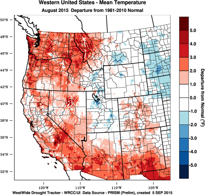
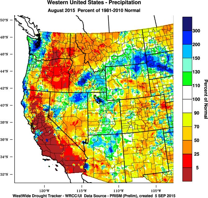
Relief … while August continued warmer than normal (see below), a change in the circulation over the Pacific and western North America ushered in an early taste of fall during the last week of the month that has continued through the first week of September. The result was a dampening of the numerous fires over the west, enough westerly wind flow to cleanse the air from a month of smoke, and cooler nights that will help with ripening. How long will it last, read on … August temperatures over the US were mixed with the plains and Ohio River Valley cooler than normal due to persistent clouds and rain, while the western US was largely above normal. Average temperatures for the month were 1-4°F above normal in California, Oregon, Washington and Idaho (Figure 1). A few areas in the western regions were near normal or slightly cooler than normal due to cloud cover and precipitation during the month. The pattern can be seen in the August precipitation map (Figure 1) where portions of the central coast of California, portions of Washington and areas in central and northern Nevada were wetter than normal. However, the majority of the western US is still experiencing severe to exceptional drought conditions with long term persistence likely.
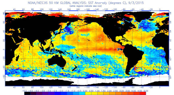
While this seems like a broken record, the trend from previous months of much higher than average nighttime temperatures continued in August over much of the western US. Again, this is largely the result of the warmer than normal sea surface temperatures in the North Pacific (Figure 2) and should continue into September and likely beyond (see forecast discussion below). Growing degree-days continue at slightly above to record numbers throughout the west. Washington has seen the largest increases in degree-day accumulations with totals as of September 1st running 10-15% over 2014 and 30-35% over the 1981-2010 averages. Heat accumulation in California is currently running right at or slightly above normal in California. For Oregon April through August accumulations are running 5-15% above the record numbers seen in 2014 (see the Appendix figure for four locations in Oregon) and 30-35% above the 1981-2010 climate normals. Most regions throughout the western US have started harvest with early ripening varieties and sparkling wine varieties in process. All other varieties are lining up for harvest but the recent shift to cool nights will allow for some timely queuing for flavors to develop. Many have reported this to be the earliest harvest since 1992 or earliest ever at their sites.
Figure 1 – Western US August 2015 temperature departure from normal (top) and percent of normal precipitation (bottom; images from WestWide Drought Tracker, Western Region Climate Center; University of Idaho).
El Niño Watch – no change from last month as all monitoring agencies worldwide continue to show and forecast strengthening El Niño conditions (warm tropical waters off South America, Figure 2). Tropical sea surface temperatures and warming with depth show a reservoir of heat energy to sustain the current El Niño. Current long lead forecasts are giving it a 90% chance of lasting through winter and 80% chance of lasting into spring 2016. However, confidence on impacts on weather in the west is not as high and runs differently depending on the reporter and news outlet (oh the sensationalism!). While it appears that the El Niño will likely bring welcomed moisture this fall/winter to Southern California, the desert SW, and the Great Basin, how far it reaches northward and how much it brings are the unknowns. As the event unfolds over the fall, conditions will become more forecastable for the rest of the winter. For general conditions commonly seen during these type of events see the Forecast Periods below for more information.
North Pacific Watch – the “blob” of warmer than normal sea surface temperatures in the North Pacific continues (Figure 2). Current index values of the Pacific Decadal Oscillation have been running strong positive, indicating that the warm phase is in place. The main result of the warmer waters is that humidity levels are up across the west, along with nighttime temperatures. The current long range forecasts continue (see below) to be driven by the combined effects of a warm North Pacific and El Niño conditions in the tropics. As detailed last month, from historical analogs (years with similar conditions), the western US would be expected to experience:
Summer (June-Sept) – warmer from the North Coast of California into Oregon and Washington, cooler from the Bay Area south and into the southwest. The cooler conditions south would be expected from increased cloud cover, precipitation, and higher humidity levels from southwest flow from the El Niño region. Thunderstorm activity during the summer from the central valley of California north into Oregon also increases during these conditions. Similar conditions in the last 30 years occurred during the 1992, 1998, 2003, 2004, and 2005 growing seasons.
Winter (Oct-Feb) – typically much warmer and drier from the northern most counties in California into the PNW and up into Canada and Alaska in most years. Near normal winter temperatures from the North Coast southward along with very likely higher rainfall amounts. However, during these types of years in the past there is a much greater risk of extreme, heavy rainfall in the winter across California and the southwest. The ultimate precipitation pattern and amounts will depend on the strength of this El Niño. (summer and winter analogs did not change from last month)
Figure 2 – Global sea surface temperatures (°C) for the period ending September 3, 2015 (image from NOAA/NESDIS).
Forecast Periods:
6-10 Day: Over the next week the continuation of a trough west of the coast will allow systems to move down out of the Gulf of Alaska and south into the western US. The main signature in the short term is for cooler than normal conditions with varied precipitation chances. It does not look like much rain, but enough in a few places to keep moisture levels higher than normal and help continue to dampen fires. From Labor Day and into next week warming and drying conditions will bring the majority of the western US back to seasonal averages and even warmer than normal extending to the 10 day outlook. Overall the 6-10 day period is forecast to end up warmer than normal across the west with precipitation being forecast for below normal in the PNW and normal south into California.
8-14 Day: Not much change from the end of the 6-10 day forecast period. Temperatures are forecast to trend warmer, especially along the North Coast of California and into Southern Oregon. Precipitation out into the two week forecast points to a continued drier than normal PNW, near normal south into California and then increasing likelihood of higher than normal into the desert SW. One thing to watch during this period is how Pacific hurricane/typhoons play out. There are numerous systems that could get entrained into the North Pacific circulation and alter the flow enough to bring rain to the west. Will need to keep an eye on them over the one to two week forecast period.
30 Day: The outlook for September points to seasonal to slightly above normal temperatures along the west coast and inland to eastern Oregon and Washington. Cooler temperatures are forecast into the Great Basin and Rockies. The 30 day forecast for precipitation is showing a high likelihood of drier than normal conditions in Oregon, while an equal chance for slightly above, normal or slightly below for Washington, Idaho and into central California. SW monsoon flow is projected to continue into Southern California and the desert SW with a higher than average likelihood of precipitation during September.
90 Day: The September-October-November (SON) temperature outlook indicates enhanced probabilities of above normal temperatures for the western US, with probabilities of a warmer than normal fall reaching or exceeding 60% in the PNW. For precipitation, the SON outlook tilts the odds to below median rainfall in the PNW, near normal south into central California and above normal for the southeastern portion of California into the Great Basin and Rockies. Developing El Niño conditions in the tropical Pacific could alter the SON outlook and will be updated here as needed.
Gregory V. Jones, PhD.
Director: Division of Business, Communication, and the Environment
Professor of Environmental Science and Policy
142 Central Hall
1250 Siskiyou Blvd
Ashland, OR 97520
Tel: 541-552-6483
email: gjones@sou.edu [/fusion_builder_column][/fusion_builder_row][/fusion_builder_container]


