Trail Talk – March 2026
AS THE SPRING SEASON rolls around in our local woodland areas, we find ourselves eager to get out to enjoy the trails. How lucky we are to live where trails abound in all directions, and where the climate is mild enough to enjoy them year-round. As the daylight hours extend further into the evenings, we find more time to be out and about, making tracks, going there.
Perhaps this is a good time to consider the nature of our trail system. During our time spent volunteering in the Jacksonville Woodlands and Jacksonville’s Forest Park, we are often the recipients of questions and comments referencing the extensive network of trails maintained by trained volunteers answering to Jacksonville’s Public Works Department. These last few months, a few more pressing questions have been asked. And, as this introduction implies, it’s time for some Q and A:
Why the 10mph speed limit on trails for mountain bikes?—In the Woodlands, trails are multi-use, as are the majority of trails in Forest Park. A 10mph limit is a reasonable effort to maximize safety for visitors where two-wheeled users have opportunity to come upon two-legged users. At 10mph, bikers can stop in a reasonable distance to yield right-of-way to hikers. In the Woodlands, dogs are on leashes, and higher speeds where a leashed animal might be spooked are not conducive to safe travel. In Forest Park, confined to the tight canyons of Jackson Creek Watershed, multi-use trails are necessarily narrow to avoid unnecessary erosion of the fragile hillsides.
Throttled e-bikes are not allowed on park trails. What is the reasoning behind this ordinance?—When any bike engages a throttle, additional power is sent to the wheel. On the fragile soils of the Klamath Geologic Province, where our parks are located, throttled wheels often spin, adding to erosion of trail surfaces. The City of Jacksonville has an obligation to prevent unnecessary erosion into Jackson Creek. Keeping the trails open year-round requires special care, especially during the wet season. While Jacksonville’s trails are off-limits, there are multiple nearby trail systems that allow throttled e-bikes.
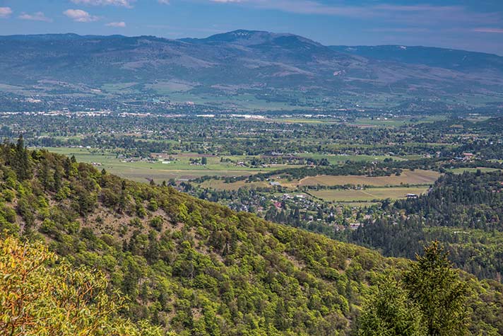
Where can hikers get the best view of Bear Creek Valley?—Both the Cascade Crest Shelter and Upper Twin Peak viewpoints provide extensive views of the valley. However, the newest viewpoint on the Bear Ridge Trail offers the overall, best view. An additional view from the trail of Grayback Mountain (think Oregon Caves) and Red Buttes is also visible.
What is the Avenza App and why is it useful?—While many map apps are available to upload onto cell-phones, we recommend Avenza for a couple of reasons. Firstly, it’s free, and as updates to maps are made, the app reflects those changes with a fresh upload. Secondly, while many apps show the Jacksonville trails, they are often inaccurate due to open source uploads that don’t reflect proper designations for trail usage. Thirdly, the Avenza map, produced to the high standards of Benchmark Maps, accurately reflects correct trail mileages, bench and viewpoint locations, as well as “You Are Here” kiosks.
Please enjoy your spring hikes. The wildflowers are here!
Featured image: Forest Park View by Skip Stokes
 Trail Talk is a monthly column by Clayton Gillette about hiking the Jacksonville Woodlands trail system. For more information, please visit the Jacksonville Woodlands Association website at
Leave A Comment