The Forest Park continues to improve and expand under the guidance and work of the Forest Park Volunteers and the city Parks Department. The volunteers have identified several new trail locations needed in the Forest Park. These new trail routes are developed by first studying the trails map and then using the National Geographic TOPO software to plot a general route to build a new trail. The goals of creating trail loops and reaching view points and shady creek bottoms in the Park are always part of the process. The next step is to walk the potential route following the general path developed on the mapping software. During this hike, initial clearing is done with chain saws and loppers, and flagging is hung as well. GPS points are then plotted using the software and human visual sighting. The TOPO program will draw the potential trail as flagged, and even draw a profile of the route, pointing out any accidental steep areas in the trail while computing the average steepness in the grade. Armed with this knowledge, the team again goes out and adjusts the flagging and does more infill flagging. The trail construction now has a detailed route to follow using nationally-accepted standards for slope, drainage, and connections to other trails. Trail-building will resume this winter so be sure to look on the kiosks for a map of the new trails and how they connect to existing ones. Currently, six miles of new trails have been identified, with over half being brushed out and flagged. When starting-out, look for the new sign in the big parking lot located up from the reservoir that reads, “To Norling Trail.” The sign points down to a just-built bridge crossing over Jackson Creek to the Norling Trail that runs parallel to the stream. Using this parking lot and new bridge is a great way to access Norling Trail, the Rail Trail as well as trail heads to O”L Miners Trail and Boulder Trail.
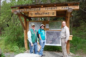
 Trail Talk is a monthly column by Tony Hess, Gary Sprague & Bob Budesa about hiking the Jacksonville Woodlands trail system. For more information, please visit the Jacksonville Woodlands Association website at