A Day on Bald Mountain
 Ever wonder as you are driving down I-5 in the Rogue Valley between Ashland and Medford what it would be like to be on top of the ridgeline to the west? We can tell you – the view is spectacular in all directions. But don’t take our word for it, come up and hike along part of the route the Siskiyou Upland Trails Association (SUTA) has proposed to link the trails of Jacksonville and Ashland. The proposed Jack-Ash trail will largely follow historic trails along the ridgeline such as the old trail linking the former Wagner Butte and Anderson Butte fire look-outs – as well as existing dirt roads. While not a formally approved trail yet, you can still hike along these lovely ridges.
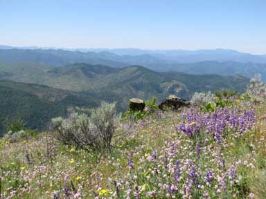
Our recommended “taste of the Jack-Ash” hike is the trial to Bald Mountain. It’s about a 3.5 mile hike out and back depending upon where you start. It passes through deep forest and ridgetop meadows with views in all directions. Thankfully at this altitude you will NOT encounter any poison oak but you will find loads of wildflowers in June and July – long after they’ve disappeared down in the valleys. This trail goes through some old Douglas Fir stands and has a wide variety of wildflowers, from orchids to false Solomon’s Seal, a wide array of succulents and wild roses tucked into rocky outcrops, and meadows covered in lupine, paintbrush, balsam root, to name a few.
 You begin hiking up a relatively shallow grade to reach the ridge leading to Bald Mountain. The trail wanders up and down and offers vistas across the entire Rogue Valley and up toward the Crater Rim (you can wave to the folks way down on I-5). There are one or two unnamed summits you will pass before reaching the highest point of Bald Mountain. The trail then descends across a rocky area and ultimately takes you out to a large meadow on the flanks of Bald Mountain with breathtaking views of the Applegate Valley, the Siskiyou Crest, Red Buttes, Grayback Mountain and more. The meadow is the perfect place to stop for a snack before returning. This is a minimally (or maybe not at all) maintained trail but its not difficult to find and follow. Once we gain approval for incorporating this route into the Jack-Ash Trail, there will be trail signs and trail clearing work done but for now, enjoy a hike on the wild side.
There are multiple routes to get to the Day on Bald Mountain hike. A BLM Ashland Resource Area Transportation map, or the Talent USGS Topo map is recommended. You can reach the take-off point from multiple directions – Jacksonville, Talent, Medford or the Applegate Valley. While this is not a long hike it takes a little while to drive up to the starting point because of the winding BLM roads. One route is to take Griffin Creek Road, and then turn onto Anderson Butte Road (not to be confused with Anderson Creek Rd). Follow Anderson Butte Road to the end of the pavement, turn hard left and follow this BLM road (38-2-24). You will pass an intersection known as Section Line Gap where Anderson Creek Road comes up on the left from Talent and Rush Creek Road comes up from Little Applegate Road – another route choice. At this point the BLM road number becomes 39-1-18 but you do not have to make any turns. From Section Line Gap, go about another 1.5 miles until you reach a point where roads go in seemingly every direction – about 4 miles from where the pavement ended. One road heads downhill to the right, one goes downhill to the left ultimately reaching Wagner Creek Road, but don’t take either. Instead, take the middle road (#21.3) slightly uphill. You can park and start your hike here or drive the much narrower dirt road #21.3 to where the trail leaves the road about 1 mile up, past a very large rock outcrop. Park at the wide area on the right where others have obviously parked. The trail begins on the right and leads up into the forest. Enjoy the hike, and don’t forget your camera!
More information about SUTA at www.SUTAOregon.org.